"You start with impossible and go from there" - Oyster Jim
Parking
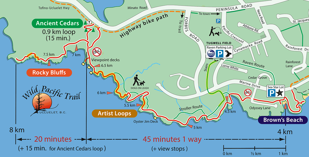
The main parking area is at Brown's Beach Frog Lot. You can also park at the Raven Parking Lot at Tugwell Field on Forbes road, then walk or cycle the bike path along the highway to the trail just 10 minutes away. Please leave bikes at the trailhead, bikes damage the trail and are unsafe for other trail users. A rack is located at the southern highway trailhead. Parking along the highway is not recommended.

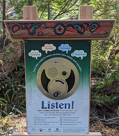
CMT interpretive sign at Ancient Cedars
Learn about how cedars planks were harvest over hundreds of years without killing the tree.
Toilets at all main trailheads, but no water
A portable toilet is provided at the northern Ancient Cedars trailhead on the highway into Ucluelet.
Keep the trail wild!
Please pack out doggie bags and anything you carry in. There is no clean-up crew following you! Please also stay on the trail to keep vegetation intact. Side trails into the forest or on to rocks are often wildlife paths and should not be followed. The forest has many layers of trees growing on fallen logs so solid ground is a maze of cavities that will collapse under foot.
Ancient Cedars & Rocky Bluffs section
Ancient Cedars Loop: 15 minute walk (off coastal Rocky Bluffs section)
This 1 km loop was built in 2013 and upgraded in 2025 into a Yuułuʔiłʔatḥ interpretive tour of this old growth forest. A unique audio box can be turned to hear how to pronounce First Nations plants and concepts. Thanks to Yuułuʔiłʔatḥ elders and experts for their leadership in building this experience.
Grade is very easy until a short hilly section on the bluffs. Allow extra time for stops.
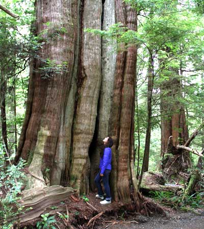
The Ancient Cedars Loop showcases old-growth Sitka spruce, western hemlock, and giant red cedars (the oldest trees on Ucluelet peninsula). Two behemoths are estimated at over 800 years and one measures more than 12 metres around its base. The cedar’s natural hollowing makes it difficult to determine exact age. One fallen old specimen clearly illustrates countless rings – imagine the thunder as this giant fell. As you walk, consider what these surviving cedars have withstood – gale-force winds, lightning strikes and perhaps even the local tsunami 300 years ago. Click here to learn more about rainforests.
Carefully hand-hewn through old-growth rainforest, this trail showcases the natural beauty of this special environment, including untouched examples of gigantic nurse-logs, "walking cedars" cascading across the forest, raised root systems, mosses, fungi, lichens and ferns. Photographers will especially appreciate unique opportunities to capture close-up images of rainforest delights. Rainforest Trail in the national park is another place to learn about old growth forests.
Cedar, the tree of life
Cedars remain key to coastal life and once provided the local Yuutu?it?ath community with sturdy seafaring canoes for fishing and whale hunting. Trees were harvested only after years or even generations of careful study to ensure they would be strong enough to withstand the open ocean. Canoe makers were always taught from a young age about trees, and before harvesting would perform a ceremony to acknowledge the tree’s gift. Carving still thrives today. These life-giving cedars also provided building materials and medicines. Bark stripped from one side of carefully selected trees continues to be woven into clothing, hats, and watertight baskets by skilled artists. Scars from this practice are called CMTs or Culturally Modified Trees. CMTs are protected by law. A significant plank harvest tree features an observation deck and historical signage.
Help us protect these special trees, do not climb or damage tree bark. These iconic trees are shared by thousands of people.Learn more about traditional uses of cedar.
Rocky Bluffs
1.5 km one way (20-minute stroll one way from the highway)Grade is easy until a short hilly section on the bluffs.
Don't miss the increasingly spectacular viewpoints across the Rocky Bluffs as you pass the protected “sea lion pool” behind a barrier reef. Watch the surf for seals and sea lions and the rocky headlands for an “eagle sentry point” at the 8 km marker viewpoint. This section feels very wild and is the furthest from Ucluelet.
Oyster Jim recommends it as “a fantastic place for storm watching!” Deep water pushes through the surge channel to scour these rocks. “That’s why we’re so high above the tideline.” STAY ON THE TRAIL, bare rocks are frequently pounded by the surf.
Lighthouse Loop Section | Artist Loop Section

Ucluelet's Wild Pacific Trail
Photos | Wildlife | Storms | Kids | Rainforest | Green Building Practices | Links | History | Oyster Jim | Map PDF | FAQ's |EMAIL
Report errors to Schramm Design — Website is copyrighted, no images can be used without written permission. Site updated 2025.